 From the U.S. Army Corps of Engineers:
NORFOLK, Va. (March 25, 2013) -- Waterman and residents on the tiny, sinking island of Tangier worry every time the winds blow through the fishing community at more than 30 miles per hour.
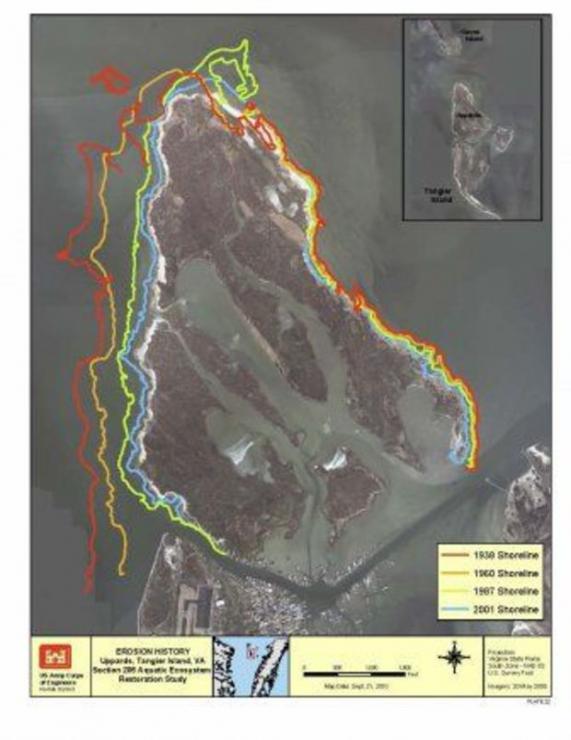
The island, located in the Chesapeake Bay just below the Maryland and Virginia border, is sinking and eroding away -- a dilemma that's expedited by churning storm waters.
"We take a pounding out here whenever a storm with 40, 50 or 60 mile-an-hour winds hit us," said James Eskridge, the mayor of Tangier and waterman. "We lose more shoreline."
But residents aren't the only ones keeping an eye on the winds. A team of engineers and researchers with the U.S. Army Corps of Engineers, Engineering Research and Development Center, Coastal Hydraulics Laboratory in Vicksburg, Miss., is gathering wind data.
Dave King, Ph.D., a research hydraulic engineer, is supervising the effort in Mississippi.
King said because the area is open to the Chesapeake Bay and the mouth of the Potomac -- up to the first major bend -- it's a 30 to 40 mile area that, if the wind is blowing in the right direction, can generate "significant" wave action.
The combination of wind and waves in the navigation channel and harbor has caused considerable damage during the recent storms.
Read the entire feature by clicking here.
Tuesday, April 2, 2013 - 15:35
 From the U.S. Army Corps of Engineers:
NORFOLK, Va. (March 25, 2013) -- Waterman and residents on the tiny, sinking island of Tangier worry every time the winds blow through the fishing community at more than 30 miles per hour.
The island, located in the Chesapeake Bay just below the Maryland and Virginia border, is sinking and eroding away -- a dilemma that's expedited by churning storm waters.
"We take a pounding out here whenever a storm with 40, 50 or 60 mile-an-hour winds hit us," said James Eskridge, the mayor of Tangier and waterman. "We lose more shoreline."
But residents aren't the only ones keeping an eye on the winds. A team of engineers and researchers with the U.S. Army Corps of Engineers, Engineering Research and Development Center, Coastal Hydraulics Laboratory in Vicksburg, Miss., is gathering wind data.
Dave King, Ph.D., a research hydraulic engineer, is supervising the effort in Mississippi.
King said because the area is open to the Chesapeake Bay and the mouth of the Potomac -- up to the first major bend -- it's a 30 to 40 mile area that, if the wind is blowing in the right direction, can generate "significant" wave action.
The combination of wind and waves in the navigation channel and harbor has caused considerable damage during the recent storms.
Read the entire feature by clicking here.